𝗢𝗯𝗹𝗶𝗾𝘂𝗲 𝗔𝗲𝗿𝗶��𝗹 𝗣𝗵𝗼𝘁𝗼𝗴𝗿𝗮𝗽��𝘆 𝗳𝗼𝗿 𝗨𝘁𝗮𝗵 𝗖𝗼𝘂𝗻𝘁𝘆
𝗦𝘂𝗺𝗺𝗲𝗿 𝟮𝟬𝟮𝟭 𝗢𝗯𝗹𝗶𝗾𝘂𝗲 𝗔𝗲𝗿𝗶𝗮𝗹 𝗣𝗵𝗼𝘁𝗼𝗴𝗿𝗮𝗽𝗵𝘆 𝗳𝗼𝗿 𝗨𝘁𝗮𝗵 𝗖𝗼𝘂𝗻𝘁𝘆
Utah County planners, you may know of this, but in case you don't: Utah County hosts August 2021 cardinal 45-degree oblique angles aerial photography on its Assessor website.
1. Look up a location utilizing the parcel map, here:
https://maps.utahcounty.gov/ParcelMap/ParcelMap.html
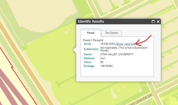
2.. Click on a parcel in the desired area. A identify dialogue box will appear. Click the "Land Info" link.
3. A property record will appear. Click on the "Aerial Image"
- The rotator compass will give you different oblique viewpoints.
- The advance arrows ["1 of 3 (or more)] will give you many different photos, especially if you change the "Select Date" field to "All Imagery."
- The PDF icon allows the export of the image, although I just prefer to take a screenshot.
Hope this is helpful. Please share with anyone you think may benefit from using this resource.
| Judi Pickell Executive Manager Phone: 801-450-2659 Email: admin@PROTECTED PO Box 1264 American Fork, UT 84003 @apautah
|


- This mailing list is a public mailing list - anyone may join or leave, at any time.
- This mailing list is a group discussion list (unmoderated)
-
Start a new thread, email: utahapa@cachempo.org
Utah Chapter APA
Privacy Policy:
Email addresses will not be shared or sold.